
Rivers on the rise
Moisture-heavy clouds that were backed up all the way to West Texas and the Gulf of Mexico kept a tappety-tap-tap of raindrops going for the second day Tuesday and will keep soaking southwest Missouri and southeast Kansas into Thursday, forecasters said.
Spokesmen for the National Weather Service in Springfield and University of Missouri Extension in Nevada said Tuesday that the rains had saturated the region since the pervasive cloud bank had first revealed its intentions around mid-afternoon Monday.
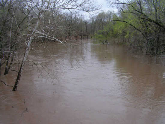
Many livestock tanks, creeks and rivers had reached the flood stage and would continue to overflow, said NWS meteorologist Mike Griffin late Tuesday afternoon. "The Osage River at Horton and Marmaton River at Nevada and Fort Scott, Kan., are moderately flooded," Griffin said.
Asked if the situation could reach emergency levels, he said, "It doesn't appear that way unless something drastically changes.
"A low pressure system stalled across West Texas is allowing this moisture to move up from the Gulf of Mexico and cause round after round of showers and thunderstorms. It's not moving east or west, just due north."
Griffin said 2.5 inches of rain had fallen in Nevada by 7 a.m., Tuesday, along with five inches at Neosho, 3.5 at Joplin, 2.5 at Appleton City and four at Fort Scott. "Things are saturated along the southwest Missouri-southeast Kansas border and U.S. 71 corridor," he said.
"A lot of the major streams and rivers are flooded. The rain will continue at least through Wednesday and may slowly taper off by Thursday. There is not much rain east of the Ozarks."
Missouri Extension Agronomy Specialist Pat Miller had recorded 2.1 inches at her home in west Nevada and she said a farm north of town had had 2.03. "It's too wet to plant corn," said Miller, noting that most of that crop is planted by early April in Vernon County in a normal year.
"Our average frost-free date is early April, so we could still have a late freeze, which we don't need," she said, explaining that the soil temperature must be around 50 degrees for corn to be successfully planted.
"The winter wheat looks good. Hopefully, we won't have flooding where the water backs up over the fields and kills the wheat. Wheat harvest should start in early to mid-June. We had some aphid problems but sprayed for them."
According to CoCoRaHS, the national Community Collaborative Rain, Hail & Snow Network, the region's heaviest rainfall, 2.65 to 4.40 inches, were recorded in Jasper and Newton counties and in McDonald County just south of there. Neosho, Mo., is about 20 miles south of Joplin.
Moisture had totaled from 1.11 to 2.64 inches in Cass, Bates, Barton and Vernon counties, according to the CoCoRaHS' Web site, with southeast Kansas precipitation ranging from 2.65 to 3.96 in the counties of Crawford, Allen, Labette, Neosho, Cherokee and Bourbon.