
Vernon County highway to transform into interstate
More than 100 years ago, an old Osage Indian trail led from the Osage villages in northeast and north central Vernon County to Fort Osage, located on the Missouri River east of Kansas City, according an article penned by the late Pat Brophy, to a Vernon County Historical Society reference called "Past Perfect."
The railroad, and later the highway, essentially followed these geographically-prescribed routes. A transcontinental roadway called Jefferson Highway was the north-south route through Vernon County; and by the late 1920s U.S. Highway 71, which followed a similar but not exactly the same route as the Jefferson Highway, was under construction.
Technology led to numerous changes to these routes over the years -- changes in surface, the specific path taken, the width and now even the access points along the road. On Dec. 12, another change will be finalized when what was once a narrow trail will officially become Interstate 49.
Peggy Pyle, vice president of the historical society, shared some thoughts on the people who built Vernon County's roads.
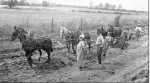
Sharing photos in a 2005 history of Vernon County of her former Deerfield neighbor, Delmer Beisly, she said, "Delmer, along with his team of mules, was hired to help build and gravel Highway 71, beginning in the Milo and Sheldon area on to Nevada. He was paid $8 a day for his work and the use of his mules."
"Past Perfect" notes that, along with motor vehicle travel, came new places for people to stay called tourist camps; the first one in Nevada was one of the first in Missouri. It was constructed by W.F. Norman on East Walnut Street in 1927-'28. There was space for camping and hotplate hookups; but little else.
A 1929 map of the state of Missouri shows U.S. 71 coming through Nevada to U.S. 54 from the north, then jogging to the east to Camp Clark before continuing south.
U.S. Highway 71, and U.S. Highway 54, which was completed in the mid- 1930s were the only paved roads in the county at the time, and remained so until the 1950s.
For many years, U.S 71 cut through Nevada, entering town on what's now Osage Boulevard; incorporating what's now known as Subway; but in the late 1960s the highway department was soliciting bids for the bypass that appears on maps by the mid-1970s.
About U.S. 54
Pyle's uncle, Homer Pettibon, told of the construction of a portion of 54 Highway at Deerfield. Known in the Civil War era as the Fort Scott/Nevada Road, then the Atlantic-Pacific Highway, U.S. 54 became a numbered highway in the 1930s. Pettibon wrote that a segment of the road through Deerfield was expensive because the road had to be elevated above the high water level. A contractor identified only as Gallagher built up the road using mules and dump wagons to transport dirt to the site. The new road, he said, "was dirt for a few years and later gravel," and still later, "it was paved with concrete," in the 1930s.
Today, highways are making history again. According to the Missouri Department of Transportation, U.S. 71 along the western edge of Missouri south of Kansas City -- a distance of 180 miles -- has been upgraded to interstate highway standards, with new interchanges, overpasses and outer roads.
The transformation of U.S. 71 to I-49 in Missouri has taken decades to accomplish. Planning for the final series of projects was begun in the late 1980s, with construction beginning in the early 1990s and continuing through 2012.
SHARE your memories
Remember when the U.S. 71 bypass was constructed and changes throughout the years? Share your stories of how highways have changed in Vernon County, and how they changed lives by sending them to editor@nevadadailymail.com.